Balk

Blog: El Paraje de las Alpujarras and Sierra Nevada walks · nature · culture · events · publications · weather
blog by: El Paraje
Berchules, Granada, Spain
Showing posts with label local walks. Show all posts

13 September 2011

Walking route PR-A 28 of Bérchules cleaned and signposted

This summer volunteers cleaned one of the must beautiful walking routes of Bérchules. At the moment two collages of this project can be seen at the town hall of Bérchules. This route is described in the visitor guide of the Parque Nacional de Sierra Nevada that was published in 2004. In this Guía de Visita it is called ´Río Grande de los Bérchules´. Unlike most other walking routes in this guide book, it was not signposted, nor mentioned on the website or brochures of the National Park. It has been waymarked this summer with yellow and white paint marks and wooden posts. This PR-A 28 of 12 kilometres is now one of the official Pequeños Recorridos in Andalucía.
The first part coincides with the waymarked Ruta de la Junta de los Ríos which is a Sendero Local. The green-and-white waymarks at the beginning have been changed into yellow-and-white, which might be confusing for people that do want to do the Junta de los Ríos walk. The last part coincides with the GR-7 that runs between Bérchules and Mecina Bombarón. It is 4 kilometres shorter than our Tajos de Reyecillo walk as we make a detour to follow the beautiful old irrigation channel up to the Cima del Tejar. Another difference is that our walk is described the other way around as we think the part between the village and the Cima del Tejar is easier to ascend than to descend (the gps track of our Tajos de Reyecillo route).


29 March 2011

Ruta Medieval through the Alpujarras

The Ruta Medieval is a beautiful linear walk connecting the villages Pórtugos, Atalbéitar, Ferreirola and Busquístar in the Taha valley and Cástaras, Nieles and Juviles. The wooden waymarking posts guide you from west to east.

We have a description and a map of a route of 20,7 kilometres from our small country hotel ´El Paraje´ to Busquístar, following the medieval paths from east to west.

Click on the image to enlarge.

This is the description and the GPS track that includes the stretch from us to Juviles.
The idea is to come back using the Granada - Bérchules bus, click here for schedules of the ALSA bus services), or arrange a taxi transfer.
profile from El Paraje to Busquístar.

Other documentation on this route PR-A299 can be found on the Spanish website of the  Mancomunidad de Municipios de la Alpujarra Granadina.

The GPS data of the whole route (including the stretch Busquístar - Pórtugos) can be found there

stage 1 Pórtugos   - Busquístar 4,7km, details  and profile
stage 2 Busquístar - Portichuelo de Castaras 4,2 km, details and profile
stage 3 Portichuelode Cástaras - Nieles 5,6 km, details and profile
stage 4 Nieles - Juviles 6,5 km, details and profile

A nice two day round trip suggestion might be:
day 1: Pórtugos or Busquístar to Juviles (or El Paraje) following the Ruta Medieval
day 2: Juviles (or El Paraje) to Trevélez and Busquístar (or Pórtugos) following the GR7

The web Recuerdos de Castaras has a comprehensive article about the oficial spanish leaflet on the Ruta Medieval.

Click here to search accommodation per village.


Related keywords: alpujarras, hiking through the sierra nevada, wandelen, wandelingen, wanderung, B&B in Berchules, hotel, hostal, hostel, , trektocht door bérchules, hiking, trekking through Andalusia, standplaats vakantie, wandelvakanties, holiday, urlaub, vacances, GR7 wandelpad

7 March 2011

Ruta los tres barrios de Trevélez

In the booklet ´Rutas por Trevélez´ information can be found on a village stroll that takes you through the three neigbourhoods of Trevélez.This route is called ´Los tres Barrios´ as it takes you through the Barrio Bajo, Barrio Medio and Barrio Alto. In the booklet this map can be found with 19 points of interest. These are explained in a text of which we made a copy (Click on this copy from the booklet to read the Spanish text).


Related key words:  alpujarras, sierra nevada, wandelen, wandelingen, wanderung, B&B, hotel, bérchules, trektocht, hiking, trekking, standplaatsvakantie, wandelvakanties

2 March 2011

Viola odorata or Common violet

Lower down in the valleys the first spring flowers can be enjoyed. Yesterday we did the small walk of 2 kilometres of the Alquería de Morayma, a rural hotel close to Cádiar. While walking their waymarked Sendero Local ´Las Acequias de la Alquería´ we marvelled at the number of white narcissuses (or narcissi), known as Narcisus cantabriun, close to the patches of holm oak wood. Returning along the acequia or irrigation channel we saw many dark violets, the Viola odorata. Closer to the Alquería we also saw the first Cynoglossum cheirifolium subsp heterocarpum in blossom. To see such a large number of flowering plants on a sunny first of March is quite special.
PS On the third of March we saw this sweet violet also along the Ruta Medieval between Juviles and the cementary of Tímar which must have been if flower mid February.


Related key words: sweet violet, english violet, common violet, garden violet, violeta común, violeta de jardín, maarts viooltje, duftveilchen, märzveilchen, wohlriechendes veilchen, violette odorante, viola odorata violaceae, viooltjesfamilie,veilchengewächse, alpujarras, sierra nevada, wandelen, wandelingen, wanderung, B&B, hotel, bérchules, trektocht, hiking, trekking, standplaatsvakantie

24 February 2011

Senderos Locales Trevélez

In 2010 a number of local walks of Trevélez were newly waymarked and documented.
These are:
SL-A 78 ´Sendero del Peñabón´ a circular walk of 7.3 km 
SL-A 79 ´Sendero del Horcajo´ a linear walk of 8.7 km   
SL-A 80 ´Sendero del Puerto de Jérez´ a linear walk of 4 km   
SL-A 81 ´Sendero del Chorrillo´ a linear walk of 6.6 km 
Maps with (Spanish) description can be found in this PDF on the FEDAMON website

The small booklet ´Rutas por Trevélez´ is now available as well. In this publication information can be found on these four routes, but also on the ruta los tres barrios, Molino Altero, Siete Lagunas, GR-7 y Sulayr (GR-240), Mulhacén por el Chorrillo, Mulhacén por Siete Lagunas and Laguna de Vacares. This booklet can be obtained at the Ayuntamiento (958858501) or the Trevélez tourist information point (650039185).

Today we went up the Mulhacén using the route Sendero del Chorillo to reach the south ridge of the Mulhacén. The waymarking to find the start  of the SL-A81, the GR7 to Busquístar and the GR240 to Capileira has been improved. But from 2,200 metres to the Chorillo at 2,730 metres the waymarking is still poor. In the summer finding the track will not be a problem, but now only a few old posts can be seen above the snow. Without a GPS track we would not advise people that are not familiar with the route to go up with snow or limited visibility. Technically the route gave no problems today, but the route is steep and snowshoes or crampones were needed with the present amount of snow.
Going on to the Mulhacén summit over the ridge was a pure joy (apart from losing our wind :) with the fantastic weather we had today. On the photo we look back south to the Mulhacén II (3,361 m).
While walking  down from the Chorillo back to Trevélez, the soft melting snow required quite some concentration. To walk from Trevélez (1,500 m)  to the Mulhacén (3,482 m) and back, an average hiker should calculate 9 to 10 hours.


Related articles:
- El Paraje now has crampons available
- See all mulhacen related articles

Related links:
-Trevélez decide recuperar los caminos más representativos del Parque de Sierra Nevada, article written by Rafael Vílchez published in the Ideal 15-08-2010

Related key words: alpujarras, sierra nevada, wandelen, wandelingen, wanderung, B&B, hotel, bérchules, trektocht, hiking, trekking, standplaatsvakantie,wandelvakanties

31 January 2011

Sendero Local Pedro Antonio de Alarcón in Torvizcón

This year we had a large number of sunny days with nice temperatures in January, which means that in the lower parts of the Alpujarra the almond trees started to blossom relatively early. To enjoy this spectacle we decided to check the Sendero Local ´Pedro Antonio de Alarcón´. This is a linear walk of 8,3 kilometres that connects Torvizcón with the Venta del Chaparro, close to Haza de Lino. The height difference between the village and the ridge road - the GR 5204 - with its spectacular views is about 700 metres. The route is named after the Spanish author Pedro Antonio de Alarcón, who travelled through the region on mule back in the spring of 1872. In his travel book ´La Alpujarra´, he described the steep climb up from Torvizcón as one of the most demanding stages. As we felt like enjoying the almond blossom in a leisurely way, we got ourselves dropped off at the highest point in order to be able to walk down to Torvizcón. We had downloaded the GPS track from the website of Alpujarra Turística and found out that this is essential to find the route. There are wooden marker posts, but the waymarking is done in one direction only, starting in Torvizcón. There are also a number of cairns, but not enough to find the small paths that are often a bit hidden between the vegetation. Sometimes you need to cross vineyards, almond and fig orchards and when they are recently ploughed you tend to stay on the dirt tracks instead of entering the fields. These are the things that make the route really attractive though. It feels as if you enter into the heart of the Sierra de Contraviesa. In all directions we saw thousands and thousands of almond trees in full blossom and got completely submerged into this show for hours with only peace and quiet around us. The nice thing about walking down is that we could also contemplate the snowcapped Sierra Nevada in front of us all the time.


Related articles:
- Publication ´Senderos Locales de la Alpujarra´
- Centro Temático del Vino Alpujárride in Torvizcón
- Almond blossom routes in February 2009

Related links:
- The Almond Blossom Appreciation Society, an article on this book written by Chris Stewart from his website Online El Valero

Related key words: almendros en flor, amandelbloesem, wandelen, wandelingen, hiking, Alpujarras, B&B, hotel

2 January 2011

The Cork Oak forest of Haza del Lino

When a guest asks for a suggestion for a nice drive to the coast, we always mention the route that passes Cádiar and then follows the GR 5204 to Haza del Lino, from where you go down to the coast passing the tranquil villages of Polopos or Sorvilán. The vineyards and almond and fig groves of the Sierra de la Contraviesa are incredibly beautiful and the views are breathtaking in all directions. Haza del Lino is a small hamlet that breathes both the air of the coast and of the mountains. The popular Restaurante Haza del Lino is a nice place to have a drink or lunch (closed on Tuesdays). For cyclists it is a pretty tour as well (See road map and route profiles) 
We now also have a suggestion for a walk that starts at this crossroads and that goes up the Cerro Salchicha, with an altitude of 1,542 metres the highest peak of the Sierra de la Contraviesa. This walk of 8 kilometres is different from any of the other walks that we offer for various reasons. Firstly because on a clear day you have impressive views of the Mediterranean Sea and secondly because it passes for a large part through a unique Cork Oak forest. The Quercus suber is a type of tree that you can be found in other parts of the Alpujarra, but it is the only Cork Oak forest that is preserved in the eastern part of Andalusia. The trunks of the harvested trees have an attractive rust red colour. When the sun shines on them and you see many of these stripped cork oaks you get the feeling of walking through a fairytail wood. The ´alcornocal´ of  Haza del Lino is the highest Cork Oak forest of Spain and possible of the world.
When you do not feel like climbing the 320 metres to get to the top of the Monte Salchicha you can wander around through this Cork Oak forest following the tracks that you see on our map. They are all broad, easy to find and follow tracks. We turned right at waypoint 03, altough the ´classical routes´ go left at this point. We went down the fire breaks between waypoints 07 and 09, which was the least attractive part of the walk. (here our GPS track) If you do not want to descend on the broad, steep fire lanes you can go back to waypoint 06 and continue straight on from there.
Haza del Lino also has a singular chestnut tree (perimeter of more than 9 metres at the base) which can be found along the road to Órgiva, on our map halfway between waypoints 01 and 02 (see detailed description of the Castaño de Haza del Lino).


Related articles:
- Centro Temático del Vino Alpujárride in Torvizcón

Related links:
- Alpujarras road map
- Road cycling with Vamos Cycling in Cádiar

Related key words: alcornoque, kurkeik, kurkeikenbos, Alpujarras, Sierra Nevada, wandelen, wandelingen, trektocht, standplaats vakantie, hiking, trekking, Berchules, B&B, hotel, wanderungen, wandelvakanties

13 December 2010

Local walk PR-A 70 Pueblos del Poqueira


We know of our own guests that many people that decide to spend a few days in the Alpujarra like to visit the Barranco de Poqueira. Quite often people are interested in combining a stroll through the picturesque villages of this beautiful valley with a short walk. We were therefor happy to learn about a ´newly´ signposted Pequeño Recorrido developed by the Parque Natural de Sierra Nevada connecting Pampaneira, Bubión and Capileira. More information on this Sendero Pueblos del Poqueira PR-A 70 can be found on the website of the Junta de Andalucía. On the map of this walk it is not made clear whether you can cross to the other side of the valley at point 6. Before arriving at Capileira (point 6 on the map) there is a sign indicating ´Puente El Molino´. It turned out to be surprisingly easy as well as beautiful to follow the indications and cross the bridge. At the other side there is a sign of the PR-A 70 indicating the way back to Pampaneira. Having two circular walks everybody can decide how to combine visiting the Poqueira villages with some hiking. The ´low loop´ is about 6 kilometres and the first part coincides with the GR-7. Both routes follow the old ´Camino a Bubión´. At the Plaza Libertad in Pampaneira a GR-7 waymark can be found. Going up Calle Estación, you pass an old wash house and climb up Calle Principe or Calle Real to get to the starting point. On the street map or ´plano´ of Pampaneira the starting point of the ´Camino a Bubión´ can be found. On the street map of Bubión we indicated where the PR-A 70 enters and leaves the village. The ´high loop´ that passes through Capileira is about four kilometres, but it is also possible to return to point 6 on the map in order to shorten the walk. On the street map of Capileira it is indicated with number 4 where you enter the village and number 3 is where the local walk leaves the village (coincides with the GR-240 or Sulayr).


Warning:
The PR-A 70 is quite well waymarked with signs indicating the distances to the villages and wooden posts with yellow-and-white waymarks. Where needed we placed a few extra cairns.
Nevertheless, about 200 metres of the path that steeply descends to the river before getting back to Pampaneira are seriously damaged (See our own map between 13 and 14!)!
While doing any of the walks that use the Pampaneira river crossing, like the Sendero Local La Atalaya, you need to be aware that you need to cover this difficult steep stretch with lose slates. Without clear visibility, good hiking boots and mountain walking experience this part is not to be recommended.
Take into account that the waymarking (again!) has only been done in one direction! You can get lost walking back if you did not look back every now and then. (No problem with our GPS track data of course)
We have not done the ´high loop´ yet, but we heard at the Punto de Información de Pampaneira that this walk can be done without encountering any difficulties.

9 December 2010

Sendero Monterrey Laujar de Andarax

Laujar de Andarax is a village in the Almería province that we planned to visit for a long time and today we finally came around to do it. Thanks to the new Almería-Lanjarón road the travelling time is now only forty-five minutes and the weather forecast for today mentioned twenty-four degrees, sunny and no wind. A perfect day to check out one of the walking routes starting from this village that is quite well-known for its wines. The Sendero Hidroeléctrica is famous, but we heard at the Centro de Visitantes that it is not maintained as there are some steep stretches that are not considered safe enough. We decided to do the shortest of the two ´official´ short  local walks (signposted with yellow-and-white waymarks) of which we received copies at this visitor´s centre, namely the Sendero Monterrey (pdf folleto 3,86 mb) a circular walk of nine kilometres. The first three kilometres you follow a beautiful small path through a dense pine forest. Although you do not climb much more than three hundred metres, the views are fantastic once you come in a more open lanscape with grape vines growing at 1,200 metres. The return route is for a great part on a wide dirt track with fantastic views. We could not cross the Río Andarax easily, but we think this was exceptional. The holes of the bridge were blocked, so that the water ran over it in stead of underneath. Besides, the river was probably very swollen because of the amount of rainfall last week in combination with the melting snow. The snow that covered the Almirez (2,519 metres) and the Pico del Buitre (2,465 metres) a week ago has all been gone by now. A few hundred metres after having crossed the river with some difficulties the path has disappeared - probably as a result of the heavy rains last winter - and it looks as if you might need to cross the river again. This is not the case though, you need to stick to the left bank of the river for 200 metres although there is no clear path any more. The rest of the track and the two bridges that you need to cross are no problem. We are impressed by the beauty of this valley and will definetely go back to check other routes in the area.


Our ´regulars´ know that we add new walks like this to our file with descriptions. For new readers it might be nice to know that we make our own maps, callibrate them and put our GPS data and waypoints on top of them. (click here for our GPS data of this walk). At waypoint 9 we investigated the situation of the damaged dirt track to find out that sticking to the left bank of the river does the trick. We did not edit (delete) this part of our GPS data.


Related keywords:  Alpujarras, wandelen, wandelingen, trektocht, berchules, B&B, hotel

1 June 2010

A Peace Pole inaugurated in the Alpujarras

When we received an invitation to assist an inauguration of a ´peace pole´, it was the first time that we heard of this concept. We consulted Wikipedia and read: ”A Peace Pole is a monument that displays the message ´May Peace Prevail on Earth´, usually in a different language on each side. The message is referred to as a peace prayer. Peace poles remind us to think, speak and act in the spirit of peace and harmony.” We learned that there exists a ´Peace Pole Proyect´ and on this website we read: "it is estimated that there are more than 200,000 Peace Poles that have been dedicated in nearly every country on earth."
Joost van Vlijmen decided to place one in the Alpujarras. Unfortunately we could not assist the inauguration on Tuesday the 25th of May, but Joost sent us his speech with a few photos of the event. Yesterdag morning we decided to walk to his place to visit the monument. The peace message on his pole is in Spanish, Dutch, English and Chinese. This peace memorial, as far as we know the first one in the Alpujarras, can be found along one of the yellow-and-white local waymarked walking routes of Válor, called the ´Sendero de Launa´. It is only a small detour for the people who walk the GR-7 between Yegen and Válor to visit the ´poste de paz´ placed in the middle of the beautiful tranquil Alpujarran country side. We think it quite a special and inspirational setting as the Alpujarras is a region where many people find peace of mind. As we believe in the strength of each individual to strive for a better world, we admire this personal initiative.


The Peace Pole inauguration speech of Joost van Vlijmen:

Queridos amigos:

Ya hace dos años que durante un congreso en las islas Azores, vi a lo largo del camino, un poste blanco con una inscripción de una expresión de deseo de paz en unas cuatro lenguas. Lo encontraba un gesto simpático allí en plena naturaleza en los Azores. Y cuál fue mi sorpresa el año pasado cuando vi un poste blanco semejante en Tanzania en el jardín de nuestro hotel. Y ¿qué se hace actualmente cuando no se sabe todo de una materia? Uno va a buscar en internet (googlen): Encontré que en el año 1955 en Japón alguien quería predicar el mensaje de la paz universal, en respuesta a los bombardeos sobre Hirosjima y Nagasaki. La idea es que la paz universal empieza con cada individuo y que es sensato recordar esto cada día. Una fundación vio la luz y a través de conferencias y proyectos culturales difundieron su mensaje. Una de estas iniciativas es el “Peace Pole Project”: colocar un poste con el mensaje de la paz universal en diversas lenguas. Entretanto hay en más de doscientos países más de doscientos mil postes.
En la hermosa naturaleza de las Alpujarras, con el camino GR siete aquí muy cerca, viene mucha gente a andar, así también por este sitio. Y a mí me pareció buena idea colocar un “Peace Pole” aquí de modo que muchos senderistas, paseantes, puedan verlo y llevarse consigo el mensaje en el corazón.
Ambos mis padres experimentaron la Segunda Guerra Mundial, mi madre en el campo de prisioneros de guerra en Indonesia y mi padre de joven escondido , pasando a la clandestinidad en Holanda.
Me gustaría pedirles ( a mis padres) descubrir el poste por medio de quitar el paño y después os invito a todos a tomar una bebida en el jardín de Chautari.

Related key words: vredespaal, pôle de paix, friedenspfahl, que la paz prevalezca en la tierra, moge vrede heersen op aarde, que la paix règne sur terre,  möge friede auf erden herrschen

10 March 2010

Walking connections between Yegen and Mecina Bombarón

Last week it was difficult to walk the GR7 from Yegen to Mecina Bombarón. Between Yegen and Montenegro some large rocks had blocked the path, and there was a danger of more rocks coming down. Besides, there was a lot of water running through the Río Mecina near El Golco. An emergency bridge has been made at that point, but certain days the water level was much higher than the bridge itself. As the weather improves, water levels drop rapidly and today we heard that the GR7 between the two villages no longer imposes serious problems for walkers.

Nevertheless, it reminded us of a walking route at the other side of the main road called Sendero de las Encinas. It is still on the brochure of the town hall and on the website of Alpujarra de la Sierra, although it was not newly waymarked like the other small local walks. A few years ago we tried walking this route starting in Mecina Bombarón, but we got a little bit lost as the waymarking wasn´t very good and the path was overgrown at some parts. Now we thought we would give it a try again, walking the route in the opposite direction. From the village of Yegen we followed the Sendero de la Salud, which starts next to the play ground. This route is one of the Senderos Locales that was recently waymarked anew with wooden posts with white arrows. It follows the old Camino Real, a beautiful cobbled path that took people to Granada or Guadix on the other side of the sierra.

Where the Sendero de la Salud starts to go down, you leave this waymarked route by keeping to the left. There is an old yellow-and-white sign on a chestnut tree a few metres further on, but that is about the last one you will see for about an hour. You keep going up on the Camino Real until you see a marker post of the Sulayr route. Here you go left down a dirt track towards a holm oak grove. Here you see a few very old ´encinas´, which have given this route its name. In the distance you already see the path that will take you back to Mecina Bombarón. You get to the main road close to the Fuente de los Remedios.

It is only on the last part, where you no longer need them, that you see yellow-and-white waymarks again. The Sendero de las Encinas would normally take you over the old Roman bridge back to the vilage. Unfortunately the bridge got so badly damaged, that you need to use the main road to cross the Río Mecina.

As the GR7 does not give any problems anymore, combining the two walking connections is possible again. The two make a really varied and attractive circular walk of 14,5 kilometres. In case that you find the circular route too long or strenuous (height difference of almost 700 metres), it is possible to make use of the public transport. Don´t trust the schedule you find on the website of the local bus company ALSA too much though. The first time we tried to get on the bus to Yegen it left Mecina Bombarón at 11.15 hours, half an hour earlier than the time you see on the internet and the timetable in the town hall. After asking a few people, we understood that it mostly leaves at aroud 11.30 hours. There is a bus going from Yegen to Mecina Bombarón at 15.30 hours according to the timetable on the ALSA website, but we do not now how realiable this information is.
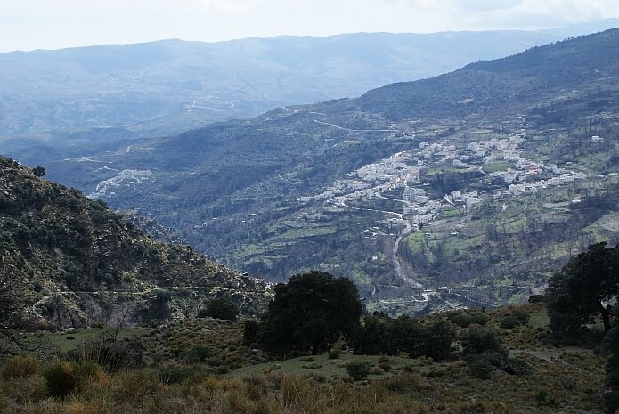
Sendero de las Encinas with Mecina Bombarón and El Golco in the background - photo: casa rural El Paraje

Related links:
All GR7 stages in the Alpujarras with maps , from the website Mancomunidad de municipios de la Alpujarra Granadina

related keywords: senderismo, rutas, wandelen, wandelingen, randonnée, promenades, wandern, wanderungen, Berchules, B&B, hotel, trektocht

1 March 2010

Junta de los Riós circular walk damaged

Our walking route to the Junta de los Ríos is a circular route that returns along the Acequia Nueva as we explained in an earlier post. We had heard that the Acequia Nueva of Bérchules suffered a lot during the recent spells of bad weather. Today we took the opportunity to see the damage with our own eyes. At some parts, the path and the irrigation channel have disappeared completely. At one point it is necesarry to cross a steep slope with loose stones. At other parts you need to be a bit agile and creative to find your way. From an easy leisurely walk the part along the acequia has changed into a challenging route only for experienced walkers. We therefor advise walkers to do the official linear walk that follows the old Camino a Lanteira. It runs a bit higher up and does not give any serious problems. It passes the Fábrica de los Moros where the two rivers join and continues up to Cortijo los Pollos. Go as far as you think you can manage, keeping in mind you walk the same way back.
It is vital that the irrigation channel will be repaired for the farmers in Bérchules and Alcútar that depend on the water from the Acequia Nueva. The restoration will be a mayor project, costly and time consuming. We hope for the farmers that money will become available to start with the repairs soon. We also hope that the restoration project will take into account that the Acequia Nueva is part of the protected heritage as we can see on the list of Bienes de Interés Cultural. Although the circular walk is not advisable at the moment, the beauty of the Bérchules river valley can still be enjoyed following the official linear walk.


related keywords: senderismo, rutas, wandelen, wandelingen, randonnée, promenades, wandern, wanderungen, wandelvakantie, wandelroutes, B&B, hotel

18 January 2010

Walking connections between Lobras and Tímar

On some walking routes in the Alpujarras you cross a river where there is no bridge. In general this should not be a problem, but at this moment of writing this can not be taken for granted. Today we found out that the rivers can be so swollen as a result of the heavy rains the past weeks, that it might be difficult or impossible to get to the other side. This we experienced while walking the GR7 between Lobras and Tímar, when we tried to cross the Río Tímar. Luckily there is now also another walking route connecting these two lovely villages, the path along the Acequia de los Castaños. In the past this was the principal walking connection. Every year less people went from one village to the other on foot, so the path became overgrown and in the end impenetrable. Thanks to an employment creation programme, this old connection was restored last year. The last day of the ´Taller de Empleo´ was on the 29th of December, right during the ´temporal´or spell of bad winter weather. Unfortunately some improvements did not withstand the heavy rains, but it is possible to follow the route without any problem. Luckily they made a proper bridge to cross the Río Tímar close to the village of Tímar. The route is not signposted, but from Lobras it is easy to find. At a crossing where you would go down towards the river following the GR7, you continue straight on along the irrigation channel. To find the route from Tímar is less easy, you need to find the old camino real next to the school building. This map gives an idea. We found it on the website with a lot of useful information on Tímar. They suggest a circular route, which will be lovely again in a few weeks or months when less water is running through the river. We can recommend the new route to everybody walking this part of the GR7. It is a more beautiful path and easier because you can avoid the steep climbing and ascending in order to cross the river. Small wooden bridge over the Río Tímar which you cross when walking the route of the Acequia de Castaños - foto: casa rural El Paraje

29 June 2009

Walking in high summer, Acequias de Poqueira

Capileira is like Trevélez a good starting point for a walk in the summer because of its altitude (1,436 metres). A number of years ago there were eight waymarked routes in the Poqueira valley, and each one was signposted with a different colour. One of our favourites was the ´yellow´ route, the Acequias del Poqueira. A few days ago, we found out that the waymarking of the routes in this area has changed. The walk ´Acequias de Poqueira´ has remained the same, but it is now an official Pequeño Recorrido, the PR-A 23. It has been newly signposted with yellow-and-white and signs with the name of the walk on some crucial points. A large board at the starting point gives now information on this itinerary of about sixteen kilometres.

The first part of the route we did in company of a farmer on his way to his cortijo. He said he was now the only person in Capileira to go with his mule to his farm where he still has a herd of goats. Until reaching his cortijo, he talked animatedly about the past and the present, his family and his farm. We continued along the river Naute trying to imagine what this area looked like in earlier times when the land around the ruined cortijos was still being cultivated. The Cortijo las Tomas at 2,100 metres is the highest farm building on this route. It is also a junction of paths, one continues another four hundred metres uphill to the manned refuge, the Refugio Poqueira. We continued on the waymarked path in easterly direction that winds around the contours between the Acequia Alta and Acequia Baja for four kilometres. It was a clear day, so in front of us we could see the Mediterranean Sea in the distance and to the right we had good views of the highest mountains of Spain. On an information board just past the Corrales de Pitres, it is explained which mountains you can see from this point. Quite surprisingly we were the only hikers to enjoy these impressive panoramic views on a Sunday with the perfect walking weather. The path passes many springs, rivers and acequias, so there was still some verdant growth that attracts lots of butterflies. It is definitely a route we can recommend, also in high summer. It is well waymarked and information on this walk incl gps track can be found on the website of the Consejería de Medio Ambiente of the Junta de Andalucía.
One of the last farmers in the Poqueira valley to go to his farm on muleback - foto: casa rural El Paraje

8 May 2009

Sendero Local La Solana in Murtas

A few days ago we checked out a Sendero Local in de Sierra de la Contraviesa. ´La Solana´ is a circular route of 4,2 kilometres that starts just off the road that links Murtas with Mecina Tedel. It offers magnificent scenery almost from the start. You follow a track that skirts round to the left of the Pico de Molino de Viento with views of the Alpujarra villages and the Sierra Nevada. Further along beautiful views towards the sea can be enjoyed on clear days. At the end of the route a small path takes you back to the village of Murtas. The number and diversity of wild flowers on this route is amazing this time of the year. In February when the almonds are blossoming it will also be a very pleasant stroll. The small circular walk is well signposted and can be done without the description from the publication of the Senderos Locales or the GPS track and map from the website of Alpujarra Turística.
View of Murtas while walking the Sendero Local La Solana - foto: casa rural El Paraje

Related keywords: Alpujarras, Sierra Nevada, wandelen, wandelingen, trektocht, standplaats vakantie, hiking, trekking, Berchules, B&B, hotel, wanderungen

18 April 2009

Senderos Locales Mecina Bombarón connected

We checked out whether it is possible to combine the two new linear Senderos Locales of Mecina Bombarón, the ´Acequia Alta´ and ´Acequia Baja´.
We started with the ´Acequia Baja´ which begins along the road out of Mecina Bombarón towards Yegen. A sign of this walk you find next to the Ermita de los Remedios. You can do this walk without a description as you can just follow the irrigation channel. Where the acequia takes water from the Río de Mecina there is a sign that says, ´Fin de Sendero Local´. Just before this sign, you see to your left a white paint waymark at the other side of the waterway. Apparently these marks have been painted to walk from one irrigation channel to the other. So following these white marks, you climb steeply up through a beautiful chestnut wood. You can´t really get lost, because at some point you will reach the ´Acequia Alta´. Then you turn left to follow this irrigation channel back to the village. There are very few new wooden posts of the Sendero Local to guide you back, but there are still quite a number of old yellow-and-white waymarks.
It turned out to be quite easy to connect the two new linear Senderos Locales and make it a circular route. In the publication of the Senderos Locales they say that the best time for his walk is in autumn to collect chestnuts. We think this route to be special at many different times of the year. On a spring day like today it is nice to see water running everywhere and the yellow flowers of the Adenocarpus Decorticans that grow abundantly along the ´Acequia Baja´ are beautiful.
Adenocarpus Decorticans along the ´Acequia Baja´ of Mecina Bombarón - foto: casa rural El Paraje

15 April 2009

Senderos Locales Alpujarra de la Sierra newly waymarked

The municipality Alpujarra de la Sierra is formed by the villages Mecina Bombarón, Yegen, Golco and Montenegro. It has four Pequeños Recorridos which we can see on an old map on the official website of the town hall, on the brochure of the municipality and on different maps of the area. Nevertheless, the yellow-and-white paint marks of these routes can no longer be relied upon. Recently the signposting of three of the walks has been done anew with wooden posts with white arrows. One route, PR A 109 or the ´Sendero de las Encinas, has fallen into oblivion.

The PR-A 112 or ´Sendero de Gerald Brenan´ is a short circular walk from Yegen. On the website of Alpujarra Turística information can be found on this ´Sendero de Gerald Brenan´. We wrote about this walk in an earlier post in which we explained that only the direction of the route changed.
The PR-A 110 or ´Sendero de la Salud´ is a short circular walk from Yegen. On the website of Alpujarra Turística information on this walk ´Sendero de la Salud´ can be found. Apart from the new waymarking nothing else about this route changed.
The PR-A 111 or ´Sendero de las Acequias´ was a short circular route that started at the Plaza Vieja of Mecina Bombarón. Now there are two linear Senderos Locales: the ´Acequia Alta´ that starts in the upper part of the village and the ´Acequia Baja´ that starts next to the Ermita de los Remedios along the A-7208. In the publication and on the website of Alpujarra Turística information can be found on these two short walks ´Acequia Alta´ and ´Acequia Baja. Along the water channel of the Acequia Baja some old waymarking can be seen altough it was never officially part of a Pequeño Recorrido. If you would need to choose between these two routes, we personally think the Acequia Baja walk to be more pretty.
PS On the website of Alpujarra Turística the length and duration mentioned for the different walks are incorrect.
Related links:
- Pequeños recorridos Andalucia (wiki)
Mecina Bombarón with Golco in the background - foto: casa rural El Paraje

Related keywords: Alpujarras, Sierra Nevada, wandelen, wandelingen, trektocht, hiking, trekking, Berchules, B&B, hotel, wanderungen

1 April 2009

Walking along the ´Acequia de Mecina´

In an earlier post, we wrote that the local circular walk ´Junta de los Ríos´ has been changed into a linear walk. This new walk follows the ´Camino a Lanteira´ to the Junta de los Ríos. Instead of following the irrigation channel ´acequia nueva´ back to the village, it continues six kilometres northwards passing numerous ´cortijos´ or farm buildings. The threshing circles are no longer used, but tomatoes and beans are grown here, there are some fruit orchards and there are a few farms for cattle breeding. After having ascended 620 metres over ten kilometres in distance, you arrive at Cortijo de los Pollos. This cortijo is at an altitude of 1,944 metres one of the highest situated farms of Bérchules. Next to this cortijo, you find a sign saying ´Fin de Sendero Local´ , in other words ´End of the Local Walk´.
As we do not like linear walks ourselves, we were challenged to see whether we could continue from here and make a loop. We found out that by following an abandoned water channel behind this farm building, we could connect to the path along the Acequia de Mecina close to where it starts taking water from the Río Grande de Bérchules. Then we knew we had found a possibility to make a circular route. By following this canal down for 7,5 kilometres we could then connect to the GR-7 to get back to the village. We did this route when there was no meltwater running down, and were curious to actually see the system functioning. Today we took the opportunity and saw water running in the first four kilometres. This is the part from where it starts taking water from the river to a branch just above the ´pista alta´ and Cortijo de Fuente Merino. Altough there was no water running from this point to the Cima del Tejar, it is still a pleasure to simply enjoy its beauty. The Acequia de Mecina is well conserved and suplies water to the village of Mecina Bombarón. It is one of the most impressive canals in the Alpujarreas that we know and it is fascinating to imagine that it has been operative from the Muslim period. Our ´Acequia de Mecina´ route has a total length of almost 24 kilometres, four kilometres longer than walking the same way back of the Junta de los Ríos linear walk, but much more interesting.
Close to the beginning of the Acequia de Mecina that takes water from the Río Grande de Bérchules - foto: casa rural El Paraje

13 March 2009

Sendero Local ´Molino Altero´ de Trevélez

The ´camino al molino altero´ is number four of the nineteen walks in the guide ´Senderos Locales de la Alpujarra´ (see also our post of 18-02-2009). More information and the GPS track of this Sendero Local ´Molino Altero´ can be found on the website of Alpujarra Turística of the Mancomunidad. It is a short stroll of two kilometres to the river, which could be a nice walk to do with children. The starting point where you find an information panel on the route, is at the square of the Barrio Medio. On here it says that you leave the village next to the ´polideportivo´ or sports ground. To get there – this is not explained - you go right to pass the town hall and the bar-restaurant of La Fragua. Continue straight on into Calle Posada, passing hotel La Fragua II. At the end of this street you bear left to find the first wooden waypost. From this point on you can follow the green-and-white waymarks to the river where you see what is left of a flour mill. On the website of the ADR Alpujarra it is explained that after a thunderstorm in the sixties of the twentieth century, the Molino altero got almost completely buried by all the water and stones that came down from the Barranco Peñabón. From this point we see to the right the Cerro de Peñabón, one of the many attractive aspects of this pleasant short walk. You return to the village on a broad track that leads you back to the church square. You need to be aware that the starting point and the returning point are not the same. If you want to make this walk longer, you could follow the Camino del Horcajo at the left bank of the Río Trevélez and continue on the small path parallel to the river.

Ruins of the Molino Altero and to the right the Cerro de Penabón - foto: casa rural El Paraje

Related article:
- Senderos locals de Trevélez

19 February 2009

Sendero Local ´La Atalaya´ not to be recommended

Today we did the second walk in the guidebook of the Senderos Locales de la Alpujarra, called ´La Atalaya´, a route that starts and finishes in Pampaneira. Information on this route and the GPS track can be found on the website Alpujarra Turística of the Mancomunidad. On this website they mention that this route is 2,5 kilometres, but this is the length mentioned for all the walks, which is clearly not correct. In the written guide it says that the length is 8,2 kilometres which seems plausible. We set off from Pampaneira towards the power station, which is situated in a sharp bend before entering this village from Orgiva. This is not explained in the description. After having crossed the river Poqueira a wooden sign leads you to the right, but apparently the path has disappeared with the recent precipitations. When you have the track on a GPS you can find your way up the hill. At a crossing with a wooden signpost, the arrow points in the direction you come from, whereas it should point to the left. After a few hundred metres you come to an area where a small landslide took place. Again with the GPS track you can try to scramble your way up the hill. Higher up you can pick up the path again which leads you to a ruined farm building. There are no signposts but the GPS track clearly crosses through a fenced off field. There´s no possibility to enter the terrain, so we decided to retrace our steps at this point. Because of the problems mentioned above, the poor waymarking and the insufficient description, this is not a walk that we recommend.
Sendero Local ´La Atalaya´ with Pampaneira in the background - foto: casa rural El Paraje