Balk

Blog: El Paraje de las Alpujarras and Sierra Nevada walks · nature · culture · events · publications · weather
blog by: El Paraje
Berchules, Granada, Spain
Showing posts with label trevélez. Show all posts

21 March 2015

Jamón de Trevélez, de las Alpujarras.

Alpujarra specialities:


Jamón de Trevélez.

What makes "Jamón de Trevélez" so special?

The special climate in Trevélez and surrounding Alpujarra villages is the reason why the people dry hams in the Alpujarras for ages.  The cold en dry mountain air makes it possible to hang the fresh hams in the "secadero" in winter and spring without losing quality.  By late spring, early summer, when temperatures rise, the ham has yet a well dried outside that protect the meat inside.  This unique mountain climate makes it possible to dry the hams without preservatives, and without man made climate steering.  The next fotos give you an impression how the process of Trevélez ham drying goes.

The salting:


The fresh hams go into a refrigerator covered with sea-salt.  The hams, all approximately the same weight, stay in there one day per kilogram ham.  So the most common fresh hams of about 13 kg stay in the salt for only 13 days.  Halfway this period they turn the top ones for the bottom ones so they get all the same amount of pressure and salt.  

The first drying:


The fresh salted hams are pushed into a same shape,  The flesh side gets a good rub with pork fat.  This protect the fresh meat.  After that the hams go in a temperature controlled area for a couple of weeks.

The curing or "curatión":


The hams move to the "secadero".  In this area the Alpujarra climate does the "curatión" or curing. This is the slow drying process where the ham loses about 30% of it's original weight.  Depending the weight of the fresh ham the "curatión" varies from 12 to 36 months.  The most produced hams dry for about 20 months, and weight after the drying between 8 and 9 kilograms.

The commercialisation:


with the stamps on the skin of the ham, the "secadero" knows when the perfect time to sell the ham has arrived.  The ham get tested, with a piercer of pig-bone, they pierce the ham on two different spots and with an experienced nose they can tell if the ham is well cured.  The ham get labeled. 

cured ham

Local marketing:

cured ham of Trevélez


Thousands of people come to visit the Alpujarras every year.  Especially the Spanish visitors can't leave the area without a ham of the Alpujarras.  So most of the "secaderos" have a shop where you can buy ham and other cured meat.  The best way to buy a ham to take abroad is to choose a complete one and let it debone.  So you get 4-6 pieces of vacuum packed ham that you can safely take home. The pieces of ham you don't cut you can keep in the freezer till you want to open them.  Leave the unpacked ham defrost and rest for a day or two and enjoy this marvelous product long after your trip to "Las Alpujarras".


Thanks to José Antonio to give me the information for this article.


4 November 2011

The Alpujarras seen through the eyes of photographer Jesus Ruiz

We found these videos of photographer Jesus Ruiz on Vimeo. It invites you to take your time and camara when visiting the Alpujarras.


Capileira from Jesus Ruiz on Vimeo.


Trevelez from Jesus Ruiz on Vimeo.

8 August 2011

De Bérchules a Trevélez por el Horcajo

Yesterday we checked out a walking route of 19 km from the Plaza de Lobos above Bérchules to Trevélez. It involves a landrover drop off at 2600m from were you start following an irrigition channel. Right from the beginning you have spectacular views of a number of the high peaks - like the Mulhacén - and you can see Trevélez in the distance. After 4 km you get to the Barranco de las Albardas from which the high Acequia de Bérchules takes part of its water. Another 2 km further on you arrive at the Barranco de Río de Jérez, the origin of the Río Trevelez and with its borreguiles a very lush place. From here you start following another irrigation channel which even in high summer is bordered by green grass and flowers. This part is not suitable for people with fear of hights, because you need to walk on small, steep stretches with loose stones. Southwards you can see on a clear day the sea in the distance and to your right the views of the Alcazaba are impressive. You get to a crossroads with a sign for the Lagunas Vacares and the Puerto de Jérez.  From this point you follow the waymarked Puerto de Jérez route to El Horcajo and from here you walk along the river down to Trevélez. More information on these routes can be found in the small booklet Rutas por Trevélez.
If you are interested in doing this walk to Trevélez, or use the Plaza de Lobos as a starting point for any other route, you can contact us for more information on a landrover ride up to this excellent viepoint. If you just want to spend a few hours high up, something can be arranged as well, just driving up is already a great experience. A nice alternative is to just walk to the Barranco de las Albardas, a great place for butterfly sighting. Here we photographed, amongst others, Dusky Meadow Browns (Hyponephele lycaon), the endemic Spanish Brassy Ringlet (Erebia hispania), Black Satyrs (Satyrus actaea), Dark Green Fritllaries (Argynnis aglaja) and the Large Skipper (Ochlodes sylvanus) with the rolled up proboscis. This photo journey gives an impression of the spectacular route ´Trevélez por el Horcajo´. Here we offer the GPS track of this walk


High mountain walking without climbing, a perfect high summer option.

Related articles:
- Rutas por Trevélez
- Horseback riding with Virgen de las Nieves from Trevélez
- Cerro del Gallo, the highest mountain of Bérchules
- Acequia de Bérchules

Related key words: wandeling, bergwandelen, hiking, trekking, las alpujarras, hooggebergte

6 August 2011

A slide show of the high route to Trevélez in high summer

Having now a better idea of the different butterflies in the area, we decided to count the number of species on an August day on the high route to Trevélez. While ascending through the pine forest we saw a number of graylings resting on trees. In a clearing we saw a Tree Grayling (Hipparchis statilinus) with marbled looking underwings resting on a stone with exactly the same colouring. Almost at the end of the forest, close to a small pond, we saw a number of Iberian Marbled Whites (Melargia lachesis). After having left the forest behind, we entered the world of slate and Black Satyrs (Satyrus actaea), there were literally hundreds of them. At 2400m we saw a Humming-bird Hawk-moth (Macroglossum stellatarum) polinizing a Centranthus nevadensis, an endemic type of valerian. Just before the highest point of the route we saw a number of Blues that we have not identified yet. On the top of the Peña de los Papos (2538m) a Purple-shot Copper (Lycaena alciphron) and a Large Wall Brown (Lasiommata maera) were sunbathing. Another highlight was the reservoir at the top of the Barranco de los Castaños were we saw more Iberian Marbled Whites, apparently they want to be near water. Here we could also take photographs of Clouded Yellows (Colias croceus), Fritillaries, Lang's Short-tailed Blues (Leptotes pirithous) and other types of Blues, all atracted by the flowering ragwort, mentha and thistles. On the descend we saw Dusky Heaths (Coenonympha dorus subsp andalusica), another Large Wall Brown feeding on a yellow thistle, a Silver-washed Fritillary (Argynnis paphia) that did not want its picture taken and more Blues while crossing a stream. In the slide show we included a Striped Grayling (Hipparchia fidia), not a very good photo but the first one we sighted ever. Apart from the fifteen different species of butterflies we counted, we also saw a number of different grasshoppers and two different types of dragonflies, a male (blue) and female (golden) of a Broad-bodied Chaser (Libelle depressa) and the striking Golden-ringed Dragonfly (Cordulegaster boltonii) near a small natural pool close to Trevélez. We made a slide show with photogrpahs of these insects and their habitats, and of course of the excellent views. For those interested in doing this route, we offer a taxi drop off to the pine forest at 1900m.  This means you could arrive in Trevélez at lunch time, when you do not get off too late, which can be nice on a warm summer day.

14 April 2011

Bérchules - Trevélez - Bérchules

The part of the Alpujarras between Bérchules and Trevélez is quite interesting for walkers. The GR7 route connects Juviles and Trevélez and there are a few possibilities to pick up this route from Bérchules and of course from El Paraje. Thanks to the ALSA bus service, it can be done as a linear walk (another option is to organize a taxi transfer).
For keen and fit walkers we offer a special connection with Trevélez (our ´high´ route) that does not bend around the mountains but that goes right over them, passing the Peña de los Papos at 2,535 metres.
If you prefer circular walks, or if you like trail running, you may consider combining the two. This leads to a 32 kilometres walk or run that really is spectacular.
This route connects El Paraje (01) with the pista forestal (06-09) that also can be reached using the access dirt track to the sendero Sulayr Gr240 from the Cruz the Juviles.
(At 04 you can choose a less steep option going west on the dirt track and connecting lower down with the pista forestal. This may be a good option for runners, see map)
From point 09 to 13 a single track leads through the pìne woods, almost up to the ridge. You follow the ridge until 15, take a small track right until 16 after which you cross the barranco. Descend to the pine woods (19) and along those pine woods to a  water reservoir (19) of a small farm house. Descend over a meadow another 400 metres to the border of another pine forest (20 chalk crosses on big stones!). A clear track zigzags down and connects with the GR7 (21).
From 21 to 27 the GR7 is well waymarked. At point 24 the Sulayr goes left steeply up, while we continue straight on.  Where the single track of the GR7 reaches a dirt track (27) you can go on to Juviles or go left, leaving the GR7 and follow a beatiful shortcut to El Paraje.
This is the GPS track of the route. For guests we have a more detailed description in English, Dutch and Spanish at El Paraje, together with a print of this map.


Related key words: wandelen over de GR7, trekking through the sierra nevada, wandelroute, B&B, hotel in de alpujarras

7 March 2011

Ruta los tres barrios de Trevélez

In the booklet ´Rutas por Trevélez´ information can be found on a village stroll that takes you through the three neigbourhoods of Trevélez.This route is called ´Los tres Barrios´ as it takes you through the Barrio Bajo, Barrio Medio and Barrio Alto. In the booklet this map can be found with 19 points of interest. These are explained in a text of which we made a copy (Click on this copy from the booklet to read the Spanish text).


Related key words:  alpujarras, sierra nevada, wandelen, wandelingen, wanderung, B&B, hotel, bérchules, trektocht, hiking, trekking, standplaatsvakantie, wandelvakanties

24 February 2011

Senderos Locales Trevélez

In 2010 a number of local walks of Trevélez were newly waymarked and documented.
These are:
SL-A 78 ´Sendero del Peñabón´ a circular walk of 7.3 km 
SL-A 79 ´Sendero del Horcajo´ a linear walk of 8.7 km   
SL-A 80 ´Sendero del Puerto de Jérez´ a linear walk of 4 km   
SL-A 81 ´Sendero del Chorrillo´ a linear walk of 6.6 km 
Maps with (Spanish) description can be found in this PDF on the FEDAMON website

The small booklet ´Rutas por Trevélez´ is now available as well. In this publication information can be found on these four routes, but also on the ruta los tres barrios, Molino Altero, Siete Lagunas, GR-7 y Sulayr (GR-240), Mulhacén por el Chorrillo, Mulhacén por Siete Lagunas and Laguna de Vacares. This booklet can be obtained at the Ayuntamiento (958858501) or the Trevélez tourist information point (650039185).

Today we went up the Mulhacén using the route Sendero del Chorillo to reach the south ridge of the Mulhacén. The waymarking to find the start  of the SL-A81, the GR7 to Busquístar and the GR240 to Capileira has been improved. But from 2,200 metres to the Chorillo at 2,730 metres the waymarking is still poor. In the summer finding the track will not be a problem, but now only a few old posts can be seen above the snow. Without a GPS track we would not advise people that are not familiar with the route to go up with snow or limited visibility. Technically the route gave no problems today, but the route is steep and snowshoes or crampones were needed with the present amount of snow.
Going on to the Mulhacén summit over the ridge was a pure joy (apart from losing our wind :) with the fantastic weather we had today. On the photo we look back south to the Mulhacén II (3,361 m).
While walking  down from the Chorillo back to Trevélez, the soft melting snow required quite some concentration. To walk from Trevélez (1,500 m)  to the Mulhacén (3,482 m) and back, an average hiker should calculate 9 to 10 hours.


Related articles:
- El Paraje now has crampons available
- See all mulhacen related articles

Related links:
-Trevélez decide recuperar los caminos más representativos del Parque de Sierra Nevada, article written by Rafael Vílchez published in the Ideal 15-08-2010

Related key words: alpujarras, sierra nevada, wandelen, wandelingen, wanderung, B&B, hotel, bérchules, trektocht, hiking, trekking, standplaatsvakantie,wandelvakanties

19 March 2010

Horseback riding with Virgen de las Nieves

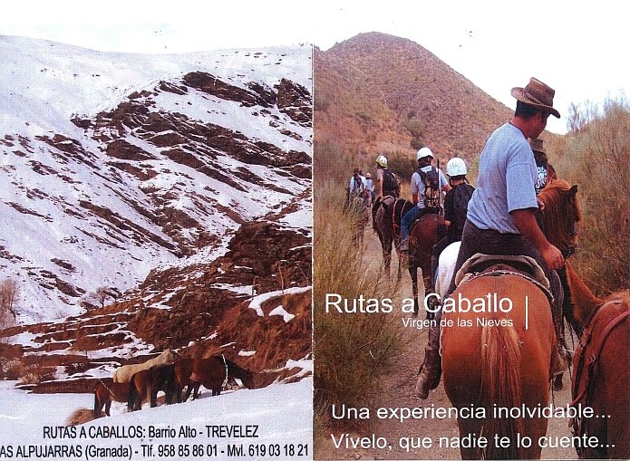
There have been a lot of horseback riding initiatives in the Alpujarras, but only a few survived over the years. For guests that would like an excursion of a few hours, our suggestion is Virgen de las Nieves in Trevélez. It is officially registered and insured, but you will not easily find anything on the Internet. The contact point is the small bar in the upper part or ´barrio alto´ of the village of Trevélez that has the same name. We offer their leaflet here below, but cannot link you to any website. This Spanish family will offer you a truly Alpujarran experience.
Rutas a caballo Virgen de las Nieves
Barrio alto de Trevélez
tel: 958 858601 mobile: 619 031821 (José Antonio)
Rutas a caballo Virgen de las Nieves - photo: leaflet copy 

Leaflet inside text:
Ven, cabalga con nosotros. Si ya sabes montar, disfruta de nuestros espléndidos caballos, pero si aún no has aprendido, déjate enseñar. Tenemos todo tipo de caballos. Dóciles, para aprender y rápidos para disfrutar; educados como niños, nobles y sencillos. Conocemos cada punto como si formase parte de nosotros. Por nuestras rutas discurren los paisajes más bellos jamás soñados, impressionantes montañas y cristalinos ríos se entrelazan entre perpetuos valles de forma maravillosa.

Vertaal huidige pagina naar het Nerderlands  Een nederlandse ervaring October 2010
Voor het opdoen van bijzondere paardrijervaringen is een verblijf in El Paraje zeer geschikt. Je kunt je mengen in de lokale bevolking en rondrijdend als een cowboy kun je genieten van de schitterende omgeving. Vanuit Berchules rij je in een half uur naar het hoogst gelegen dorp van Spanje, Trevelez. In het hoogst gelegen deel van het dorp (barrio alto) woont Jose Antonio, een local met hart voor zijn paarden. Hij heeft een stal met drie paarden. Je kunt (met handen en voeten en het telefoonnummer van El Paraje) duidelijke afspraken maken met betrekking tot het paardrijden. Antonio staat open voor alle suggesties en is erg zorgzaam, hij past de ritten aan op ieders wensen, ook als je al onderweg bent. De ritten variëren van een uur tot hele dagtochten van 8 uur. In alle gevallen ga je de bergen in. Je gaat (letterlijk en figuurlijk) door diepe dalen, langs steile afgronden, je steekt riviertjes over en je komt tot duizelingwekkende hoogten.
De ritten zijn voor ruiters van elk niveau toegankelijk. Voorwaarde is wel dat je goed moet kunnen zitten en dat je eventuele hoogtevrees kunt bedwingen. Het is zeker de moeite waard om eventuele angsten te overwinnen want het landschap is uniek en wanneer je één met je paard door de bergen rijdt waan je je alleen op aarde!

Regi en Peter


Related links:
- horse riding trail holidays with
Dallas Love , Sierra Trails in Bubión
- horse riding per hour as well as trails with
Cabalgar Rutas Alternativas in Bubión
- horse riding per hour as well as trails with
Caballo Park in Soportujar
- lessons and trails with
Caballo Blanco in Lanjarón
- lessons, riding per hour as well as trails with
Camino Verde in Busquistar
related keywords: montar a caballo, paardrijden, équitation, reiten

24 June 2009

Walking in high summer 2009

´El Paraje´ is situated at 1,400 metres and is therefore always cooler than the coast or the cities. Nevertheless it can be quite warm for serious walking in the summer. We advise people to leave early and enjoy the higher parts of the Sierra Nevada. A recently tested summer walk climbs from Trevélez up to the Alto del Chorillo at 2,720 metres. With fantastic views on the Poqueira valley, it takes the path south into the direction of Alto del Portillo. Before reaching this point, at about 2,400 metres it connects with the ´pista forestal´. Following this track down 2 kilometres it connects with the GR240 or Sulayr at the Prados de las Juncias. The Sulayr brings you back to Trevélez. This proofed to be a beautiful circular walk of about 25 kilometres. With a map of the area it is possible to do this walk as there a wooden posts almost all along the way. A descripton is therefore not really needed.Views of the high sierra with the Veleta while doing a circular walk from Trevélez on the 21st of June 2009 - foto: casa rural El Paraje

20 March 2009

Welcoming spring in the Alpujarras

Today it is just a perfect day to welcome spring. It is sunny, the sky is blue and the temperature is just right to enjoy the outdoors. In the Alpujarras, the changing of the seasons can be experienced in many different ways. A few of our guests went down the GR7 to Cádiar and were pleasantly surprised about the different flowers they could photograph near the river Guadalfeo. Other guests followed the river Trevélez and marvelled at the amount of water coming down. The snow level is at the moment at about a 2,000 metres height. Walking through the snow can at some places be exhausting, but also worth the effort. It allows you to actually see the snow melting and to enjoy the sight of icicles. At the moment an enormous amount of meltwater is running through the Acequia de Mecina and there are quite a number of waterfalls to be seen. Our walk ´Acequia de Mecina´ is therefore our special recommendation for this first spring weekend.
Río Trevélez valley as seen from the bridge on the first spring day of 2009 - foto: casa rural El Paraje
related keywords: el tiempo, het weer, le temps, das wetter

13 March 2009

Sendero Local ´Molino Altero´ de Trevélez

The ´camino al molino altero´ is number four of the nineteen walks in the guide ´Senderos Locales de la Alpujarra´ (see also our post of 18-02-2009). More information and the GPS track of this Sendero Local ´Molino Altero´ can be found on the website of Alpujarra Turística of the Mancomunidad. It is a short stroll of two kilometres to the river, which could be a nice walk to do with children. The starting point where you find an information panel on the route, is at the square of the Barrio Medio. On here it says that you leave the village next to the ´polideportivo´ or sports ground. To get there – this is not explained - you go right to pass the town hall and the bar-restaurant of La Fragua. Continue straight on into Calle Posada, passing hotel La Fragua II. At the end of this street you bear left to find the first wooden waypost. From this point on you can follow the green-and-white waymarks to the river where you see what is left of a flour mill. On the website of the ADR Alpujarra it is explained that after a thunderstorm in the sixties of the twentieth century, the Molino altero got almost completely buried by all the water and stones that came down from the Barranco Peñabón. From this point we see to the right the Cerro de Peñabón, one of the many attractive aspects of this pleasant short walk. You return to the village on a broad track that leads you back to the church square. You need to be aware that the starting point and the returning point are not the same. If you want to make this walk longer, you could follow the Camino del Horcajo at the left bank of the Río Trevélez and continue on the small path parallel to the river.

Ruins of the Molino Altero and to the right the Cerro de Penabón - foto: casa rural El Paraje

Related article:
- Senderos locals de Trevélez

25 February 2008

Video impression of Granada and the Alpujarras

This video only highlights three ´musts´ while visiting this region: Granada with the Alhambra and the Alpujarran villages Lanjarón, Pampaneira and Trevélez. The Alpujarras has more to offer than these villages. Nevertheless this video is one of the few well made videos we found on the internet.

To watch the video in a higher resolution:
Once started , 480p shows up in the lower bar. Click to choose 360p to watch the video in a lower resolution.